Section 28: Distance Markers
(Page 2 of 2)
|
On a section of the West Coast Main Line between Bushey and Hemel Hempstead, large yellow boards with black roundels [28.15] were installed on both sides of the railway in 1992/1993, attached to the electrification masts situated nearest to each quarter-milepost. The boards face in both directions along the track. These 'sighting distance devices' were provided to assist staff working on the line in assessing sighting distances, and they have no relevance to train drivers. It was originally intended to equip the entire route between Primrose Hill and Rugby with these devices.
|
 |
[28.15] Sighting Distance Device.

Area: Bushey - Hemel Hempstead
Usage: Medium
Status: Uncertain
|
|
|
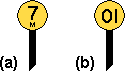
In the Manchester Piccadilly area, extra markers have been provided midway between the quarter-mileposts. These markers are of similar style to the mileposts but quote the mileage in miles and yards [28.16]. The number of yards in the lower figure can be 220, 660, 1100 or 1540, which equates to one, three, five or seven furlongs, respectively.
|
 |
[28.16] Miles and Yards Marker.
Area: Manchester Piccadilly
Usage: Medium
Status: Uncertain
|
|
In some complex areas around London, small yellow lineside markers are installed at intervals of one chain [28.17]. There are eighty chains to one mile. Similar markers are installed at the London end of the Great Western Main Line [28.18], where in addition there are metric markers provided at ten metre intervals from the zero point at London Paddington [28.19].
 |
 |
 |
[28.17] Chainage Markers ( (a) - mile marker; (b) - chain marker ).
Area: Various
Usage: High
Status: Uncertain
|
[28.18] Chainage Marker (miles and chains).
Area: Great Western Zone
Usage: High
Status: Uncertain
|
[28.19] Metreage Marker.
Area: Great Western Zone
Usage: High
Status: Uncertain
|
From c.1998, new reflectorised mileposts were installed along certain parts of the Great Western and Southern Zones. These mileposts comprise blue diagonal boards with white figures and a white border [28.20]. They are normally double-sided and placed edge-on to the track so that they face drivers.
 |
[28.20] Reflectorised Mileposts.
Area: Great Western and Southern Zones
Usage: High
Status: Uncertain
|
|
A chainage marker may carry additional plates showing the full mileage and the Engineer's Line Reference (ELR), which identifies the route [28.21].
|
 |
[28.21] Chainage Marker showing the ELR (e.g. VIR).
Area: Various
Usage: Medium
Status: Uncertain
|
|
|
A new standard form of kilometre post was introduced in 2003, with yellow figures on a black background [28.22] to distinguish it from a milepost.
|
 |
[28.22] Kilometre Post.
Area: All Areas
Usage: High
Status: Current
|
|
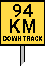
Schedule 9 of the Channel Tunnel Rail Link Act 1996 exempted that railway from Section 94 of the Railways Clauses Consolidation Act 1845 (see above). The CTRL, which opened from 2003, therefore has no mileposts, but kilometre markers are provided every kilometre. These comprise large square yellow boards [28.23] clearly visible to drivers. The name of the adjacent track is identified on each board. In addition, a plate giving the kilometrage to the nearest tenth of a kilometre [28.24] is fitted to each block marker (see [12.22]), shunt marker (see [12.23]) and group of emergency replacement switches (see [25.47]).
 |
 |
[28.23] Kilometre Marker (e.g. beside Down Track).
Area: CTRL
Usage: Medium
Status: Current
|
[28.24] Kilometrage Plate.
Area: CTRL
Usage: High
Status: Current
|
|
Distance markers are placed at 110 yard (100 metre) intervals along the Bedford to Bletchley line. This was achieved by installing three additional markers between each pair of adjacent quarter-mileposts. The additional markers give the mileage in miles and yards and also state the Engineer's Line Reference (ELR) for the route, which is "BBM" [28.25].
|
 |
[28.25] Miles and Yards Marker showing the ELR (e.g. BBM).
Area: Bedford - Bletchley
Usage: Medium
Status: Uncertain
|
|
Kilometre posts of the standard design (see [28.22]) were installed at 500 metre intervals along the Cambrian Lines in 2008 in preparation for the introduction of the European Train Control System (ETCS). They had been intended to replace the mileposts but were subsequently removed.
|
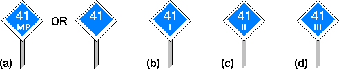
A milepost may display the relevant Engineer's Line Reference (ELR) in addition to the mileage [28.26]. This can be beneficial where routes with different ELRs and mileages run adjacent to each other.
|
 |
[28.26] Milepost showing the ELR (e.g. GTW1).
Area: Various
Usage: Low
Status: Uncertain
|
|

